
![]()
![]()
Click the logos above to join and receive
all our newsletters in your inbox.
ISSUES
4: May 7, 2024
Index
Farming For Health, Community & Resiliency
By
Randy Buchler, Shady Grove Farm
Greywater for a
Greener Future
Celebrating
our Community
Evan
Zimmermann, UPEC
As
Spring begins, we celebrate all the ways our community contributes to our
interconnected world. UPEC recently hosted our annual Celebrate the U.P.! event
at the historic Orpheum Theater in Hancock, where we welcomed experts on our
theme of Critical Lands/Critical Minerals. Karen Brzys
of Agatelady
Rock Shop brought over twenty years of mineral experience as our keynote
speaker. Steve Waller made carbon capture forests accessible. Thomas D.
Peacock read us a narrative about wolves weaving Indigenous traditions with
modern insight, and Raymond Weglarz took us on a journey through the wild
rivers and logjams of the woods. It’s people like these who live and share the
wild places in our home and hearts that make me so proud to live in the U.P.
In
this issue, we welcome contributions from people who are forging ahead with insights
into how we can live differently, stepping more lightly on the Earth and creating
a sustainable and resilient future for all of us. I’m grateful to be able to
present these insights from our community members who have taken steps forward
as examples of how we can continually rethink our relationship to the living
systems and natural resources all around us to live better lives and leave the
world a little better for having had us in it.
Farming For Health,
Community & Resiliency
Randy Buchler, Shady Grove
Farm
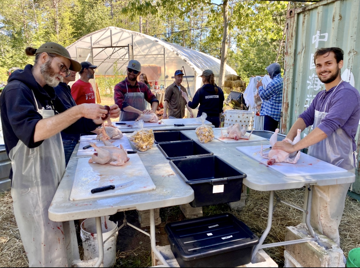
It’s a
chilly spring morning with the sun peeking over the trees and sharing its
warmth. As I sip on a cup of local coffee from my press, I think about today’s
to-do list for the farm. It’s the beginning of a new season here at Shady Grove
Farm. I must prepare my livestock areas for seeding and get the brooder ready
for 80 broiler chicks coming soon from a nearby hatchery. None of this can
happen until after morning chores. This is an exciting time of year, watching
everything come back to life. Egg production is finally full speed ahead, which
is crucial because eggs are the financial backbone of our integrative and
regenerative permaculture system.
For the last 20+ years, we’ve been building a farming system that works with
nature. Making some mistakes along the way, Mother Nature quickly suggests
something is not working and we adjust. Having an awareness of this is a
crucial part of regenerative agriculture. Through that awareness, we’ve been
successful in creating a system that has seen several species of life come back
to the property. I now see salamanders, several species of snakes, butterflies,
pollinators, frogs, toads, birds, dragonflies, lots of different mushrooms and
even hummingbird moths! It’s been incredible to see the diversity multiply over
the years. Much of this also has to do with significantly improving soil health
by meticulously managing animal manure and bedding through a specific
composting process to create life at the microbiological scale that benefits
all living organisms.
That leads me to one of the key elements of diversity when it comes to
Permaculture design, which is the concept of Polyculture. Simply put, this is
raising more than one species of plants and/or animals at the same time and in
the same system. The idea is to have a complex web of life that are beneficial
to one another, allowing the system to thrive. Our system includes chickens,
turkeys, sheep and pigs, mushrooms, and a wide array of annual and perennial
plants, flowers and fruit trees, many of which are grown on hügelkultur mounds
and some of which are grown in season extension greenhouses. The manure from
the animals, after composting, comes back into the system in the form of living
soil, which aids the system in maintaining a healthy foundation.
In addition
to the manure, the entrails, blood, bones and feathers of the animals that I
harvest on site are incredibly valuable inputs. Every animal that is raised for
food is harvested with a zero-waste set of standards. 100% of every animal gets
used, whether it’s by us, the dogs, the chickens or the compost piles… it all
goes back into the system. This is all something I’ve been teaching community
members for years, via free workshops.
One of the most important aspects of being a farmer, for me, is sharing
knowledge and teaching these skill sets to our community. This not only helps
others in being able to achieve success in their own homesteading endeavors,
but it also helps create resiliency as a community and fuels our local food
system. If we have many small farms like this in every community, along with
community members learning the skills, we greatly reduce our dependency on an
unstable and unhealthy industrial scale food system. Together we can take our
food system back!

Greywater for a Greener Future
Gracie Anzaldua
Raising
awareness in the Marquette community for water conservation by utilizing water
recycling initiatives is a promising alternative to decrease overconsumption of
fresh water. As demand for freshwater increases with the growing population and
climate change impacts, it is crucial to proactively create water conservation
techniques, such as the use of greywater systems. The term greywater refers to
the domestic use of wastewater, which can be implemented as a substitution for
consumable freshwater in utilities such as sink water and irrigation of green
spaces, in addition to flushing toilets. Greywater helps to relieve pressure of
freshwater consumption and is an effective source of water for universities,
businesses and households.
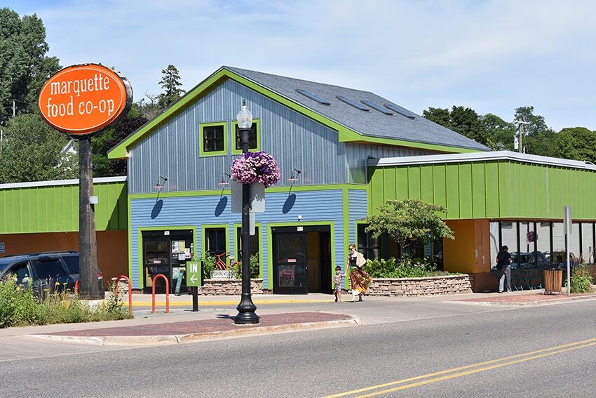
The
Marquette Food Co-op is a local business in Marquette, MI, that has installed
two simple water catchment systems for collecting rainwater to irrigate green
spaces, and refrigeration condensation to flush toilets, in attempts to
decrease waste of freshwater. Conserving freshwater by using greywater as a
substitute, or supporting local businesses that apply this initiative, are
possible options for members of the Marquette community to become more water
conscious. Recycling and repurposing freshwater is crucial even in the Great
Lakes region where reusing greywater will not only stimulate the local economy,
but also reduce overconsumption of freshwater.
The
greywater collected annually in the Marquette Food Co-op’s catchment system
showcases a small-scale example for how cost effective this initiative is, and can be useful information for other businesses or
households to determine if this is a feasible option.
Using data
gathered from a daily experiment in order to figure out how much this building
is using annually, it was
found that the Marquette Food Co-op relies on 5.5% of their water usage being
greywater. While this percentage is seemingly insignificant, the Marquette Food
Co-op is conserving 31,200 gallons of water per year, heading towards a greener
future. Based on the results of the daily data collection at the Marquette Food
Co-op and annual greywater usage, this initiative would have a positive impact
at a facility of large-scale. While the annual greywater amount saved appears
to be insignificant, the long-term impacts are substantial compared to
exclusively investing in city water.
Index
Tilden Mine
Threatens To Destroy ‘Oldest Structures In Michigan’
By Kathleen
Heideman, UPEC Mining Action Group
Michigan
considering $50M grant to Copperwood Mine
ByTom Grotewohl, ProtectThePorkies.com
A Look at
Michigan’s New Clean Energy Legislation
Nature’s Kidneys
Need Local Protection
By Superior
Watershed Partnership
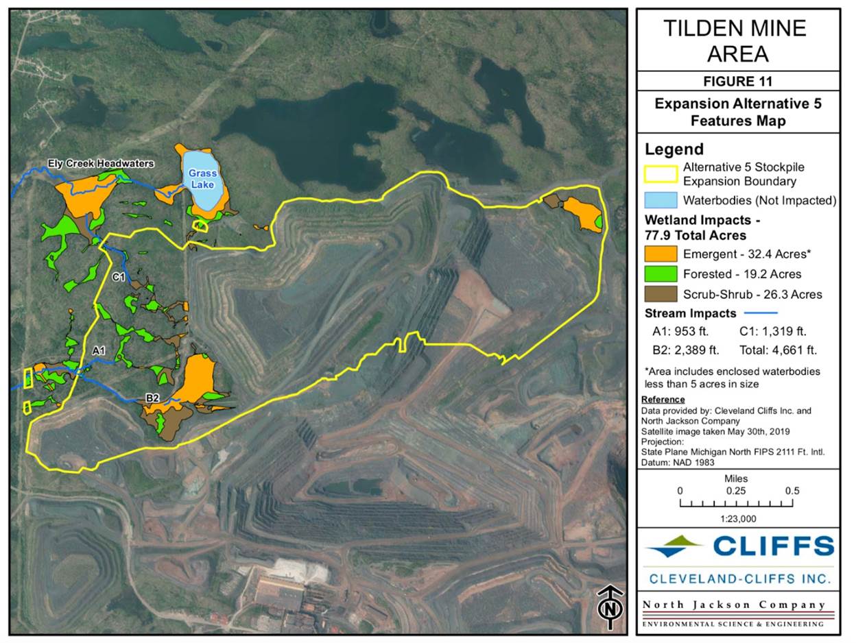
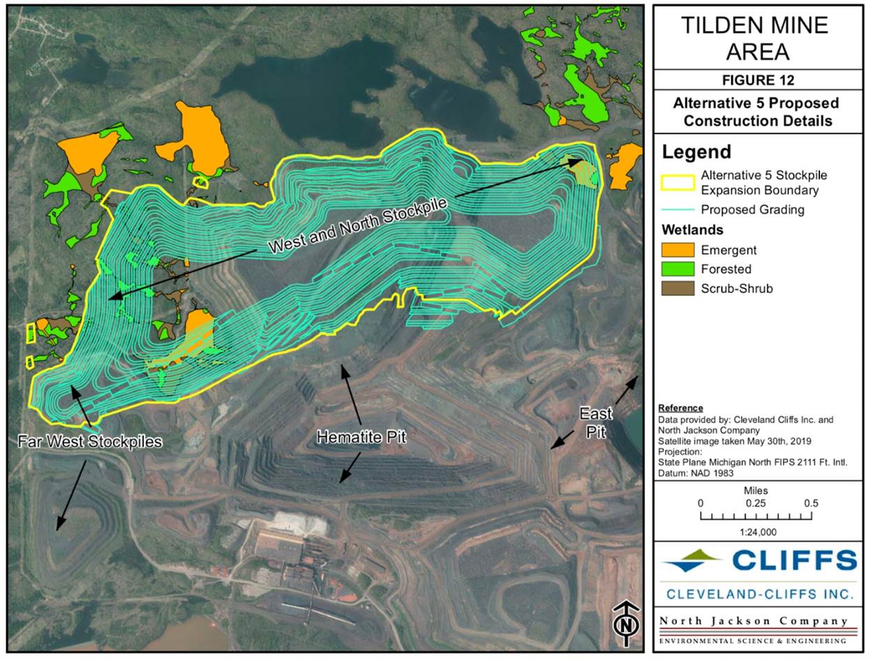
Tilden Mine Threatens To Destroy ‘Oldest
Structures In Michigan’
Kathleen Heideman, UPEC
Mining Action Group
Have you heard that Tilden Mine is
seeking a permit that would bury a landscape of historic beaver ponds under a
mountain of waste rock — beaver
dams that have been described as ‘Michigan’s Oldest Structures’? The
Tilden Mine Expansion would permanently destroy 300+ acres of land, 78 acres of
wetlands, several freshwater ponds, and nearly a mile of tributary streams
feeding Ely Creek. This is a landscape of historic eco-cultural importance,
as it was meticulously documented in Lewis Henry Morgan’s book “The American
Beaver and His Works,” published in 1868. Morgan’s favorite site was a beaver
dam on Grass Lake, which he described in his journal as "by far the
largest and most extraordinary Beaver structure I have seen and perhaps is not
exceeded by any in the country.” The Grass Lake site falls within the Tilden
Mine Expansion area.
The ever-growing environmental
footprint of iron mining is nothing new, of course: Tilden Mine and the
neighboring Empire Mine are
so large they can be seen from space. Both iron mines are
owned by Cliffs.
- The Tilden Mine Expansion impact area is
just 1.4 miles south of downtown Ishpeming, within City limits.
- Tilden’s waste rock stockpile will reach
nearly 2000’ elevation.
- The Area of Impact appears to threaten
federally protected species.
- Residential drinking water wells in the
National Mine area may be impacted.
Clearly, the TIlden
Mine Expansion proposal will have an enormous environmental impact — whether
that scope is measured by acreage of buried wetlands and lost streams, tons of
waste rock to be dumped over acres of undeveloped lands, the damages to
ecological systems and the species living in this area, or water quality
concerns within the watershed, including selenium and mercury contamination. We
believe that cumulative environmental impacts must be considered, including a
long history of interconnected permitting actions that have been piecemealed in
the past.
Join UPEC’s LiveStream
for an overview of the Tilden Mine Expansion permits, and the environmental
impacts of the project, tips on preparing public comments, and how to
participate in the online Public Hearing scheduled for February 28th.
https://www.facebook.com/upenvironment/live
To review the permit, download the
application from Michigan’s MiEnviro Public Notice
portal: https://mienviro.michigan.gov/ncore/external/publicnotice/info/3816554689198819001/documents
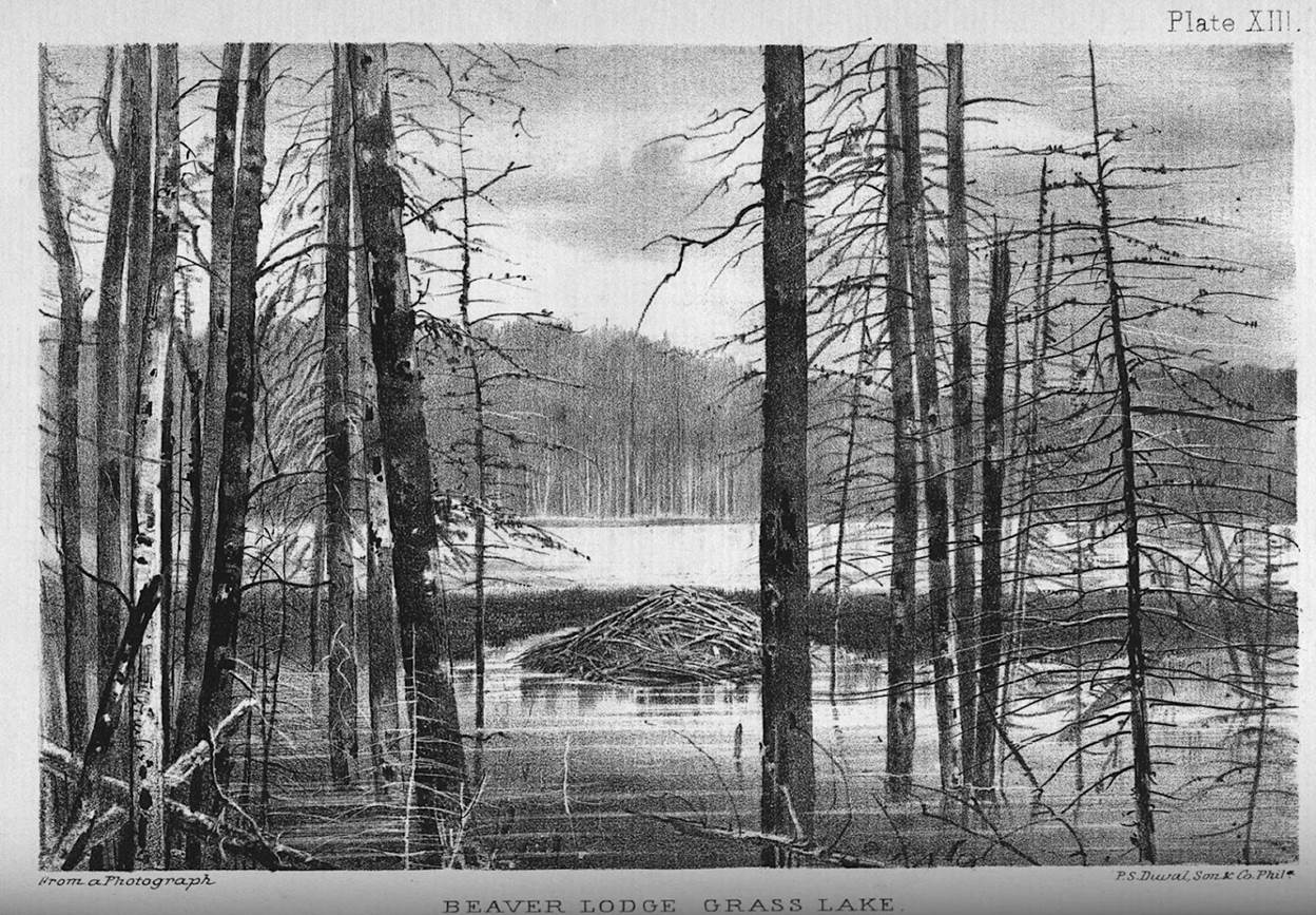
Historic illustration of Tilden
Mine Expansion project area, found in Lewis Henry Morgan’s book “The American
Beaver and His Works,” 1868.
Michigan
considering $50M grant to Copperwood Mine
Tom Grotewohl,
ProtectThePorkies.com
On January 30th, the Michigan
Strategic Fund nearly passed a $50M grant to the Copperwood
Mine. You read that right: your taxpayer dollars, paying for a foreign
company’s sulfide mine, the closest in history to Lake Superior, next door to
both the North Country Trail and Porcupine Mountains Wilderness State Park.
Fortunately, a
few MSF board members expressed doubts, and the grant was
deferred to an expedited subcommittee. The grant must be re-submitted for a
vote at the next MSF board meeting on February 27th. Registration
to make a public comment is now open. We encourage everyone
who cares about protecting freshwater seas and wild spaces to make a comment,
either virtually at the meeting or via e-mail in the days preceding.
The grant was developed over the
course of a year by the MSF’s parent organization, the
Michigan Economic Development Corporation. The MEDC is also the creator of the
“Pure Michigan” campaign, which celebrates our beautiful natural areas and
promotes outdoor recreation. Some would say that for the very same group to
propose funding Copperwood, the campaign might best
be rebranded as “Pure Hypocrisy.” But anyway, it is worth noting that
the MSF did not immediately approve a proposal by their own parent company, as
they have done in nearly every other case. This suggests that the level of
doubt is already significant, so the role of our public comments should be
to amplify it further.
The MSF Board Members are hardcore
businessfolk. They do not necessarily care about noise pollution and light
pollution. They do not necessarily know what a Tailings Disposal Facility is. But
they do care about the soundness of their investment. At the January
30th board meeting, these principle concerns were
raised:
- Why so few investors after a decade of
scrambling?
- Why fund a boom-and-bust operation that
will only run 11 years?
- And since Highland Copper recently sold
66% of their White Pine Mine to another Canadian partner, isn’t it
possible that Michigan will fund Copperwood only
for it to change hands in the same fashion?
We have several other arguments to
add to that list, as presented at our Call
to Action page, and also in our recent video, “Dear Michigan.” We
encourage you to attend one of our upcoming
Zoom strategizing sessions, in which we will provide
materials and assist in the crafting of public comments to be presented at the
February 27th MSF board meeting.
Finally, because the Michigan
Strategic Fund board members were appointed directly by the Governor, we are
asking everyone to contact
her as soon as possible and demand a rejection of the Copperwood grant.
Please remember:
there are very few humans who live in this area, so if we want to win, it
will require the help of folks from both near and far. As a reminder of
what’s on the line:
—Highland Copper has plans to mine
beneath Section 5 on Porcupine Mountains State Park property. Once this
precedent is set, they may eventually seek to mine on the other side of the Presque
Isle River.
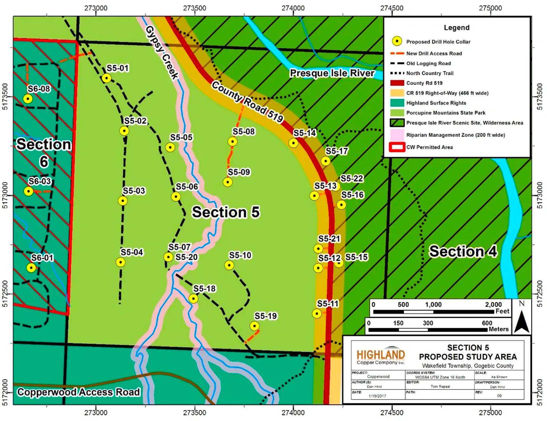
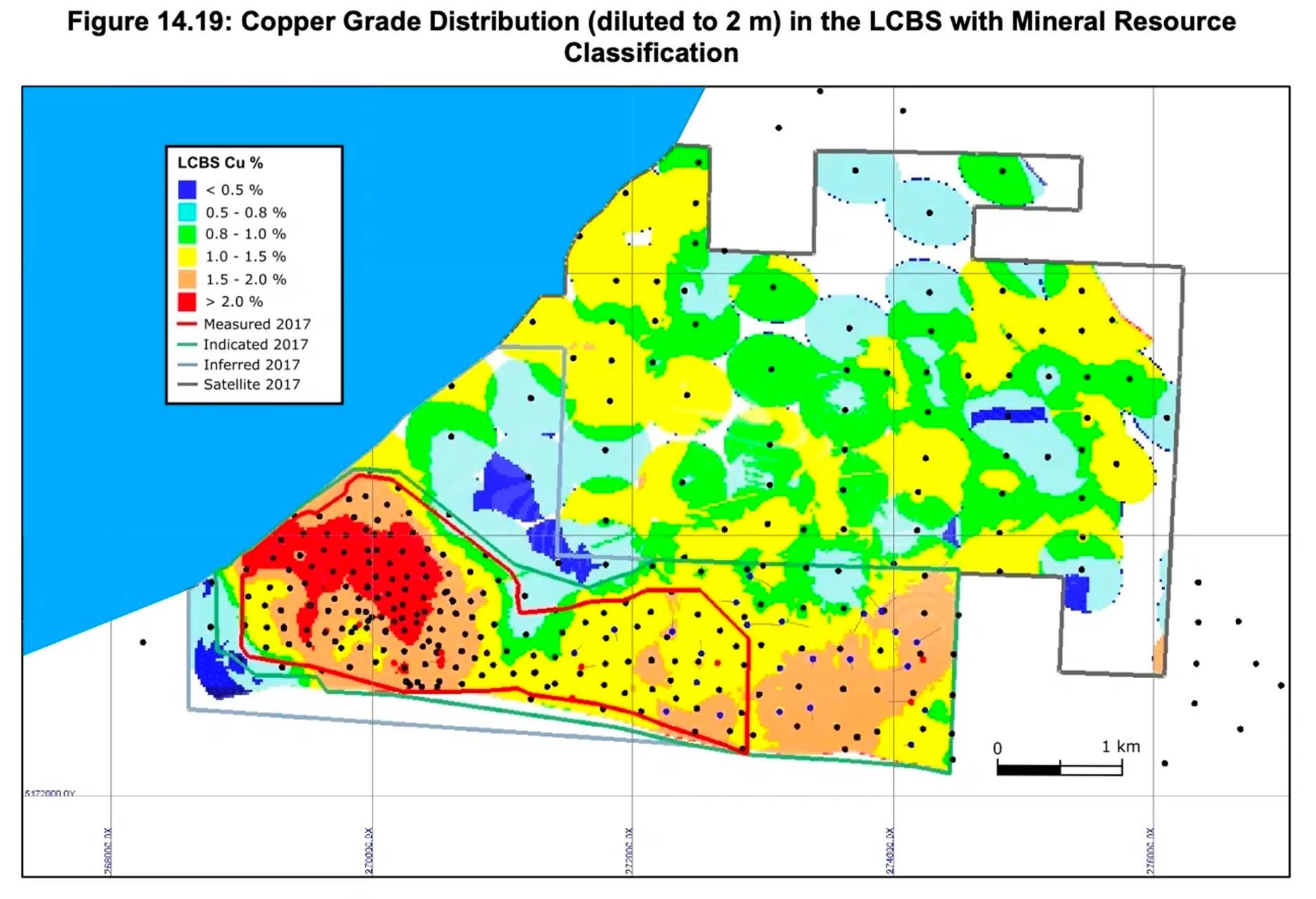
—The Grade Distribution Map
clearly shows that the best copper is closest to the Lake. For now they plan to mine up to 100 ft from the lakeshore, but
their own Feasibility Report states, “This setback distance is more related to
permitting as mining beneath the lake is possible." (pg290)
A Look at Michigan’s New Clean Energy
Legislation
By
Abry Waters, CSCLS

On November 28th, 2023, Michigan
Governor Gretchen Whitmer signed into effect the Clean Energy and Climate
Action Package, a set of four bills meant to transition Michigan’s energy grid
to renewables by 2040. These new measures are a part of Whitmer’s MI Healthy
Climate plan and place Michigan next to over twenty other US states making
plans for more clean energy standards within the next couple of decades. In a press
release, the governor highlighted the positive impact the package will have
on the state: “Together, we are fighting for our air, land, and water,
improving public health and protecting our precious natural resources for
future generations. We are building the future in Michigan.”
The
four signed bills, which will go into effect before the end of 2024,
include:
● Senate
Bill 273, which will require an increase in energy efficiency savings from
1% to 1.5% for utilities in Michigan;
● Senate
Bill 502, which requires the Michigan Public Service Commission (MPSC) to
prioritize new goals including service quality, affordability,
cost-effectiveness and equitable access when reviewing utility-integrated
resource plans, and increases accessibility for public participation in MPSC cases;
● Senate
Bill 519, which creates the Michigan Community and Worker Economic
Transition Office in the Department of Labor and Economic Opportunity to assist
workers and communities in the transition from fossil fuels to electric
technology; and
● Senate Bill 277, which
codifies a current state rule allowing farmers to lease their land for solar
projects while staying enrolled in the state’s farmland preservation
program.
Some of the package’s major
focuses include increased energy storage and efficiency standards throughout
the state, increased support for energy workers and their communities, and the requirement
for energy utilities to obtain an 80% “clean energy” portfolio within the
next two decades. The aim is to create more opportunities for renewable energy
usage and decarbonization of utilities through the state.
These changes are making strides
in the fight against climate change in Michigan; however, not everyone is in
favor of the bill's contents in their entirety, and some aspects of the package
are receiving criticism from politicians and environmental groups. For one,
S.B. 271 states that “clean energy” includes nuclear and fossil ‘natural’
gas power, neither of which are actually clean.
Another topic of criticism for the bills was the possibility that this change
over the next couple of decades could increase energy costs for Michigan
companies and Michigan residents, although this point has arguments on both
sides.
For UP residents, lack of local
control over renewables infrastructure has been a key point of opposition
against the package. Specifically under fire is S.B.
502, since it gives the MPSC authority to bypass local governments when placing
renewable energy projects. State Rep. Greg Markkanen (R-Houghton)
spoke on Yoopers' desire for freedom while also maintaining access to
affordable and reliable energy; so much of the Upper Peninsula is undeveloped,
and many UP residents don’t want to see those natural areas taken away for
solar and wind farms.
The Michigan Healthy Climate Plan,
along with the Clean Energy and Climate Action Package, demonstrate
a desire within Michigan’s state government to advocate for the health of our
environment. The job is nowhere near done, as there are still issues
needing to be addressed in the current system and important points not
addressed in these bills. Ultimately, though, this plan represents significant
progress toward mitigating climate change and creating more opportunities for
clean energy use across the state - as well as the collaboration between state
leaders and environmental advocates towards a cleaner Michigan in the future.
Nature’s Kidneys Need Local Protection
By
Jane Fitkin, CSCLS
Wetlands are an incredibly
important piece of every environment here in the UP. Acting as “nature’s
kidneys”, they are essential for water quality as they filter pollutants and
remove nutrients. Wetlands are also necessary for flood and erosion mitigation
as their soil absorbs and retains more water than other soil types, and
critical for habitat and spawning grounds for many different species of flora
and fauna. Even small, isolated wetlands effectively provide these
functions.
Wetlands once made up 32% of all
land across the Upper Peninsula. However, due largely to historical mining and
logging industrialization and nowadays to residential and commercial
development, nearly 900,000 acres of wetlands have been destroyed in the UP, a
22% loss. Every county in the UP experiences
significant wetland degradation, and loss is concentrated most heavily in
Ontonagon County, which has lost 70% (147,848 acres) of its wetlands to
date.
In June 2023, the Supreme Court
issued its decision in Sackett v EPA, a case originally about whether a
couple could fill some wetlands to build a house near a lake, which turned into
the Court further limiting the scope of the Clean Water Act (CWA). In a 5-4
decision, the Court
redefined
the CWA’s coverage of “waters of the United States” (WOTUS) to cover only (1)
relatively permanent bodies of water – like streams, rivers, and lakes –
connected to traditional navigable waters, and (2) wetlands which have a
continuous surface connection to those waters. The “continuous surface
connection” test means the wetland must be virtually indistinguishable from the
navigable, or boatable, body of water, to be protected under WOTUS. This
decision severely limits the EPA’s ability to require permits for wetland
impacts, removing authority for around 90 million acres of wetlands nationwide,
and poses consequences for other water protections as well.
Luckily, Michigan’s Department of
Environment, Great Lakes and Energy (“EGLE”) has an agreement with the EPA
giving them authority to administer the federal wetland program as well as its
own state-level program. The state has fairly strong wetland regulations,
and is able to pass stronger environmental protections than the federal
government due to a law passed in 2023 which reversed a “no stricter
than federal” law from 2018. This reduces the daunting effects of Sackett in
Michigan. However, legal analysis and education jumpstarted by the Sackett decision
illuminate the gaps in Michigan’s state-level regulations and highlight the
need for local protection.
State-level wetland protection is
administered by EGLE through Part 303 of Michigan’s Natural Resources
and Environmental Protection Act, originally passed in 1979. Part 303 requires
landowners to obtain a permit from EGLE before impacting a regulated wetland,
and contains a
mitigation component requiring most
regulated wetland impacts to be offset by wetland restoration or creation
elsewhere. Impacts requiring permits include filling, dredging, draining, or
building in a wetland. For a wetland to have protection under Part 303, it must:
● Be situated within 1000
feet of a Great Lake;
● Be situated within 500 feet of an
inland lake or stream;
● Be 5 acres or larger in size;
or
● Be determined by EGLE as
essential to the preservation of the state’s natural resources.
While these criteria provide
regulatory protection for many of the wetlands in the UP, they don’t offer full
protection, as made clear through Michigan’s extensive wetland loss. Notably,
these criteria prevent the state from regulating wetlands smaller than 5 acres
if they’re not connected to lakes or streams. This has and continues to allow
landowners and developers to destroy small, isolated wetlands, without a
permit, unless local protections come into play. Also, though they often
propose changes to applications, EGLE rarely denies permits when completed
fully and correctly. Additionally, exempted from regulation are wetland impacts
due to ongoing farming, ongoing grazing, logging, drain maintenance, fishing,
hunting, trapping, boating and other recreational activities.
That’s where local protections
can come in. Local governments are able to pass
Wetland Ordinances to regulate those wetlands protected by the state, as well
as isolated wetlands between 2-5 acres in size, and those smaller than 2 acres
but which are critical to the preservation of the community’s natural
resources. There’s even a sample ordinance on EGLE’s website. Despite
this, not a single municipality in the UP has passed a Wetland Protection
Ordinance (though some have setback requirements including wetlands).
As a state deriving so much of its
culture and pride from our clean freshwater, we sure should be doing everything
we can to protect our ecosystems’ kidneys.
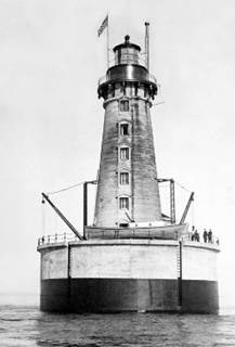
Stannard Rock
Lighthouse: How the Superior Watershed Partnership is Studying Climate Change
from the Loneliest Place in North America
By Superior Watershed Partnership
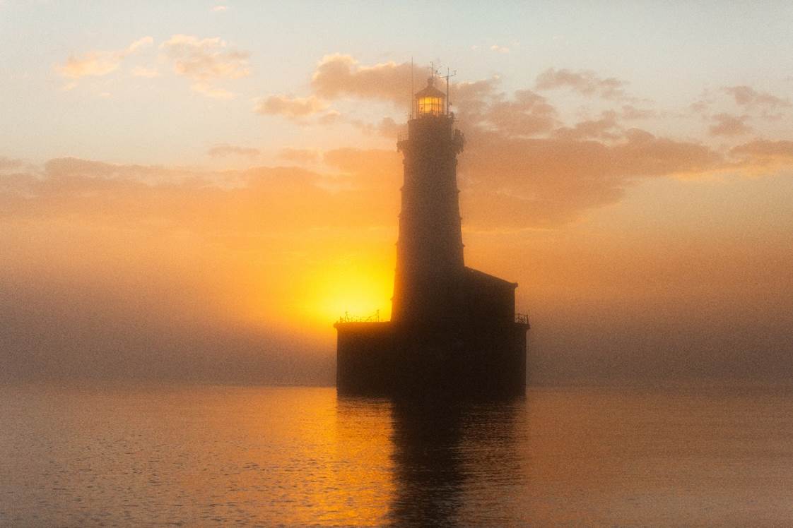
Have
you ever looked out over Lake Superior’s surface and found yourself unable to
spot land in any direction? Many miles from the nearest shore, a 110-foot tower
juts from Lake Superior; Stannard Rock Lighthouse.
Nicknamed “the loneliest place in North America” by the keepers who lived and
worked at the station for the first eighty years of its life, Stannard is a one of a kind piece of Great Lakes maritime history
currently playing a crucial role in understanding the climate crisis’ impact on
Lake Superior and coastal communities.
Stannard
marks the location of a massive reef forty-two miles north of Marquette and
twenty-five miles southeast of Keweenaw Point. The marine construction project
took over five years as builders battled Lake Superior’s lashing waves and
winds; upon completion in 1882, Stannard Rock Lighthouse was dubbed a top ten
engineering feat in American history. And for good reason. Stannard is the most
distant lighthouse from any shore in North America, bringing unique challenges
to even its basic operations.
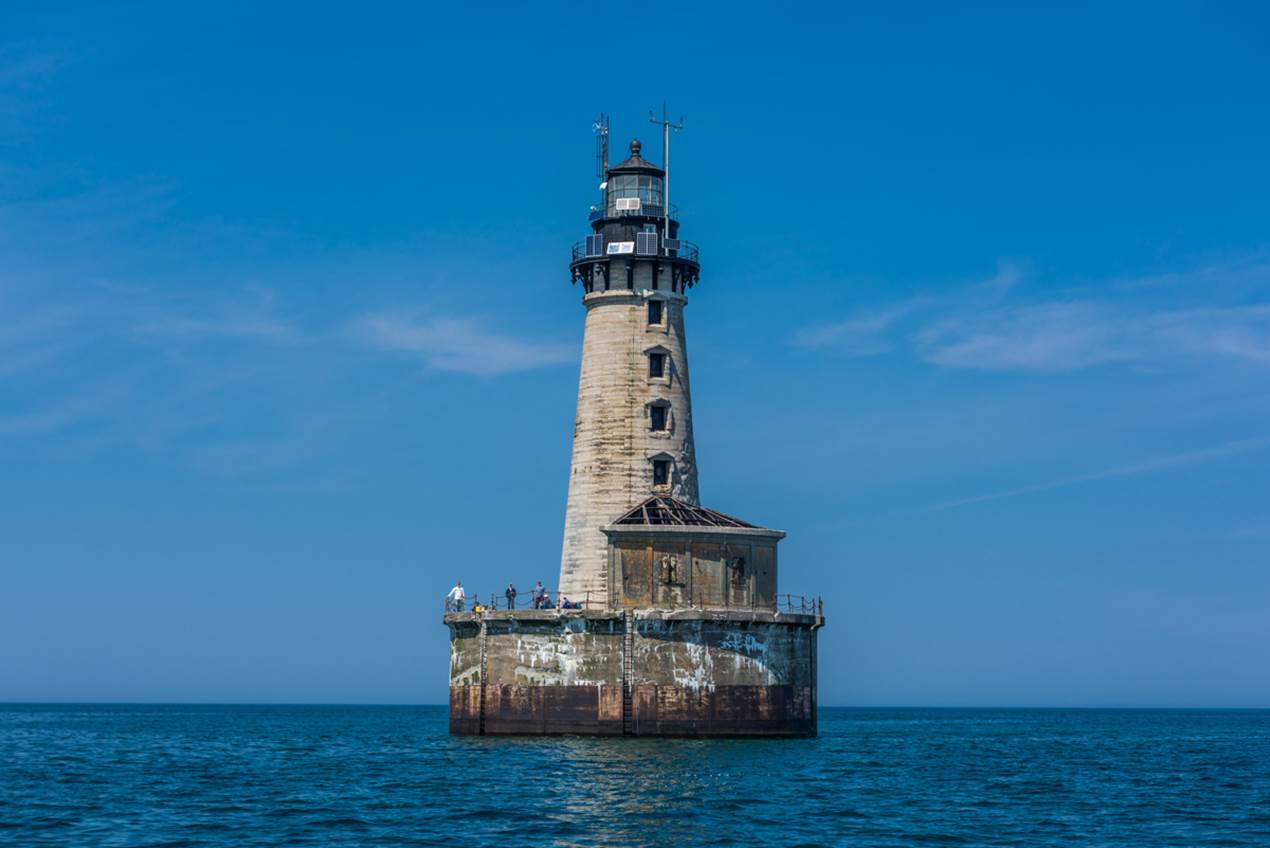
In
1961, tragedy struck when fuel stored in the station’s pier ignited, causing an
explosion and fire that killed one keeper and stranded the remaining three on
Stannard’s exposed deck. The survivors waited three days before being rescued
by a passing vessel. The following year, the lighthouse was automated. However,
as improved navigation technology reduced reliance on lighthouses, Stannard’s
future fell further into question.
While
other lighthouses in the Great Lakes have become valued purely for their
historical qualities, Stannard’s location makes it uniquely suitable for
long-term climate research. In 2015, the federal government transferred
ownership of Stannard Rock Lighthouse to the Superior Watershed Partnership
(SWP). Through domestic and international partnerships, the SWP has brought
together programming from the National Oceanic and Atmospheric Administration
(NOAA) and the Great Lakes Evaporation Network to study wind speeds, wave
intensity, evaporation, and other variables critical for understanding climate
change on Lake Superior. Unlike other monitoring stations that can’t withstand
Superior’s winter storms and ice, Stannard Rock Lighthouse provides real-time
data throughout the entire year. In 2017, sensors tracked 77 mile per hour
winds along with a 28.8 foot wave; the largest ever
recorded on Lake Superior!
In
addition to the research mission, the SWP is working to restore Stannard,
preserving its historic value as well as expanding its capabilities as a
research station. Each summer, the SWP’s Great Lakes Climate Corps (GLCC)
program coordinates teams of young adults to visit the station. These crews
clean, paint, and do other upkeep tasks while on site. However, the lighthouse
requires major renovations. The SWP is currently fundraising for these
projects; check out this webpage to learn more about the
restoration project and this link to
donate! With your help, future generations will be able to experience
Stannard’s unique perspective on an irreplaceable lake and benefit from the
crucial insight it provides on our changing climate.
Index
Reflecting on Stopping the Rocket by Jane Fitkin, citizensforsuperior.org
OWDM Responds to MPSC Decision on Line 5 Permit by David Holtz
Enbridge Line 3's aquifer breaches: A summary by Scott Russell and
Waadookawaad Amikwag
How many drops in a tidal wave? by
Chris Vaughn
Reflecting on Stopping the Rocket
By Jane Fitkin, citizensforsuperior.org
After a 3-year long campaign to Stop the Rocket, the Powell
Township Board passed a resolution late last month making it clear that a
spaceport has no place at Granot Loma. This is a satisfying conclusion to the
conversation initiated by citizens and organized by Citizens for a Safe &
Clean Lake Superior (CSCLS). But, how did we get here?
In 2018, in the outgoing days of Governor Rick Snyder's
administration, Gavin Brown of the Michigan Aerospace Manufacturers Association
(MAMA) convinced Snyder to give him $2.5 million for site selection and
feasibility studies for his Michigan Launch Initiative (MLI). The MLI was
touted to include the creation of both vertical and horizontal launch sites in
Michigan, as well as a command and control center for
them elsewhere in the state. MAMA misled Marquette County officials, saying it
was interested in the former K.I. Sawyer Air Force Base for either the
horizontal or vertical launch site. The County was excited, seeing a
potentially promising use for the abandoned base, and quickly garnered support
from municipalities, businesses, citizens, and even environmental groups for
the project.
That was, until May 2020, when Brown and County officials
stood on the steps of the County Courthouse to announce that a location had
been chosen for a vertical launch site. However, the announcement took everyone
by surprise: it wasn't K.I. Sawyer that had been chosen, but Granot Loma, a
scenic, private stretch of Lake Superior shoreline between Marquette and Big
Bay. Public opposition to the new site selection quickly mounted, fueled by a
Change.org petition that has now garnered over 26,000 signatures, but the
County as well as MAMA stood confidently behind their decision, telling us we
would see rockets launching from Granot Loma by 2025.
CSCLS formed in the fall of 2020, presenting coordinated
opposition to the Granot Loma spaceport plan. We mobilized quickly to gather
information to squash this project. Through numerous Freedom of Information Act
(FOIA) requests, CSCLS has been able to uncover
and share with the public information demonstrating that this plan was not only
unneeded, but also extremely destructive to our environment, our
recreation-based economy, and our quality of life here in the UP.
For example, as bait
to persuade County officials to support the MLI, MAMA falsely promised 40,000
new jobs statewide and thousands for the UP. However, using FOIA, CSCLS
uncovered an independent study that MAMA was required to commission as part of
the grant, but then tried to hide, which definitively debunked that false
economic benefit claim. That report by the IQM Research Institute of Ann Arbor
found that a spaceport in Marquette County was "not self-sustaining nor
economically viable," and would realistically bring negligible annual
revenue statewide.
Following the release
of the IQM report, Brown and MAMA got quiet. We've actually
heard almost nothing from them since. They obviously didn't want that
report to get out, and it no doubt had a severely negative impact on their
fundraising efforts and public image. But, as experienced environmental
campaigners know, just because a project goes quiet doesn't mean it's over. So
CSCLS didn't stop working.
In 2023, CSCLS initiated a citizen petition to amend
Powell Township's Zoning Ordinance to explicitly prohibit rocket launch
sites. Initially submitted in July 2023, and armed with the signatures of 177
Powell Township residents, the petition produced successful negotiations with
the Township Board. This resulted in the passage of an official
resolution finding that the spaceport would be "inconsistent with current
and future land uses and planning goals as defined in the Master Plan of the
Township." From now on, whether it's MAMA or another aerospace lobbyist
trying to industrialize more of the Superior lakeshore for launching rockets,
they'll have effectively impossible hurdles to jump through.
Looking back on our
efforts over the past 3 years, three words come to mind: community,
persistence, and courage. This organization is operated and supported by the
community here. We've had challenges and been bullied, but
haven't ever backed down. And we didn't let go until the job was finished.
OWDM Responds to MPSC Decision on Line 5 Permit
By David Holtz, Oil and Water Don't
Mix, david@davidholtz.org
MICHIGAN: The Michigan Public Service
Commission (MPSC) announced today that they are approving siting for Enbridge's
Line 5 Great Lakes expansion project, the largest underwater hazardous liquids
tunnel ever proposed, in the worst spot in the Great Lakes for an oil spill. In
response, Sean McBrearty, Oil and Water Don't Mix campaign coordinator,
issued the following statement:
'With this action, the Michigan
Public Service Commission is putting Michigan in uncharted, dangerous territory
while ignoring warnings by independent industry experts who testified during
the MPSC's proceedings; never before has an oil tunnel
that also carries other hazardous liquids been built in one of the most
ecologically sensitive spots on Earth.
'The proposed tunnel must still pass
a comprehensive federal environmental study before moving forward and there is
still an open question whether Enbridge intends to build the tunnel or is
simply using the project as a diversion and delay from shutting down the
existing twin oil pipelines in the Straits of Mackinac. As recently as October,
an independent study determined the tunnel and Line 5 is not needed. Moreover, the
Line 5 tunnel will worsen the impacts of the climate crisis by adding 27
million metric tons of polluting and climate altering carbon into the
atmosphere, equivalent to ten coal-fired power plants.
'The U.S. Army Corps of Engineers are
now working on the third and final permitting decision for the Line 5 carbon
bomb tunnel. Families, businesses, and Michigan communities cannot be left out
of this decision-making process. What they need is immediate action, and
President Joe Biden could do that right now by revoking the presidential permit
for Line 5.'
Enbridge
Line 3's aquifer breaches: A summary
By Scott Russell and Waadookawaad Amikwag, https://healingmnstories.wordpress.com,
edited by Evan Zimmermann.
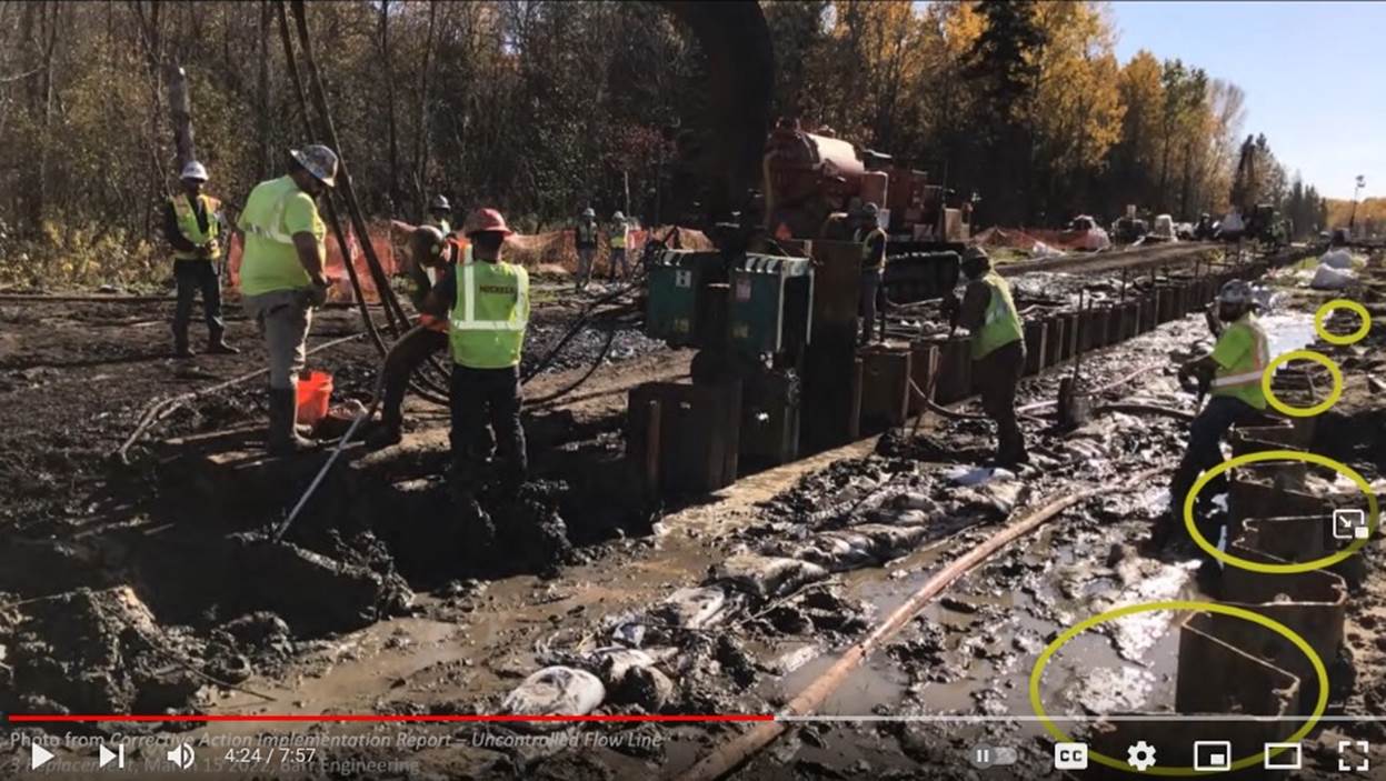
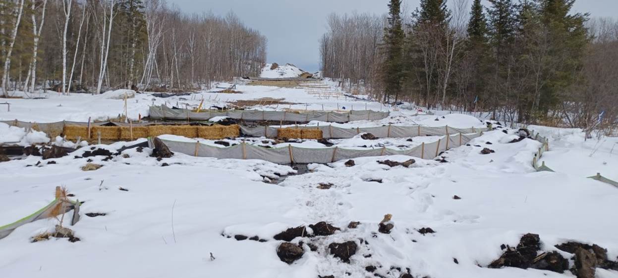
Sheet pilings laid out at a Line 3 worksite, June,
2021.
Line 3 construction ended Oct. 1, 2021. State regulators have
been slow to announce all the environmental damage that occurred. They say they
don't release information until they finish their investigations.
Line 3's 337-mile route went through 78 miles of wetlands. Line
3 also crosses lands with shallow artesian aquifers, areas where groundwater is
held underground, under pressure, by an impervious confining layer such as
clay. Break the clay seal with sheet piling and the water rushes to the
surface. So far, we know of four artesian aquifer breaches: Clearbrook, LaSalle
Valley, the Fond du Lac Reservation, and Moose Lake.
With three of the breaches, Clearbrook, LaSalle Valley, and Fond
du Lac, Enbridge pumped grout (think cement) into the ground to try to plug
them. Such Slap-Dash Efforts at LaSalle Valley and Fond du Lac haven't been
successful, probably doing more harm than good.
This summary includes Enbridge's estimates on the amount of
groundwater released by each breach. These underestimate the problem. These
breaches occurred 12- to 39-feet underwater in wetlands. The groundwater
released by the breach doesn't necessarily all come to the surface in one spot
where it can be measured. It can diffuse into the wetland before it reaches the
surface, making it impossible to track.
Workers used grout to try to plug the Clearbrook aquifer breach. Image: Enbridge report to
the DNR and MPCA.
Site: The Clearbrook breach occurred in Clearwater County in 1855
Treaty Territory. It's near the Clearbrook
Terminal, Enbridge's crude oil storage tank farm. The breach also is a
half mile from a rare 'calcareous fen.'
Cause: Enbridge said it would dig an eight-foot-deep trench, the DNR
wrote in its Sept. 16, 2021
administrative penalty order. Instead, workers dug an
eighteen-foot-deep trench and installed sheet pilings 28-feet deep, breaching
the artesian aquifer's confining layer, which was approximately 18-feet deep.
Groundwater release: 72.8 million gallons, according to Enbridge's estimates.
Slap-Dash Effort: Enbridge injected 547,692 gallons of grout underground to plug
the breach, according to Enbridge's Feb. 15, 2022 Corrective
Action Implementation Report. (That's enough grout to build a wall
two-feet thick, 20-feet tall, and more than a third of a mile long.)
Other things to know:
The public is in the dark about why this happened: It is unclear why
Enbridge deviated so far from its construction plan, or if the DNR has pressed
the company for answers. The public deserves to know.
Enbridge was responsible to report the
breech to the DNR immediately. It withheld the information for 140 days. Even then, DNR staff
only learned about the breach indirectly, according to the Sept. 16, 2021 DNR Restoration
and Replacement Order.
Enbridge's Slap-Dash Efforts were slow: It would take
Enbridge one year from the date of the breach to finish work trying to plug the
breach almost four months after it finished Line 3/93 construction. At last
report, the breach was releasing small amounts of groundwater.
Criminal charges were inadequate: Minnesota Attorney
General Keith Ellison filed one
misdemeanor charge against Enbridge for appropriating waters without a permit.
Enbridge admitted its role in the breach, the Attorney General's Office said.
Enbridge also admitted to delaying notification to the DNR. Enbridge paid a
$1,000 fine, and entered into a diversion program. If
Enbridge remained law-abiding for a year, the state would dismiss the charges.
'Unless and until the Legislature changes the law, a misdemeanor is the
only charge against Enbridge the State can support,' Ellison said in a
statement.
Potential damage to rare fens: The breach's 'uncontrolled flow has reduced
groundwater resources supplying the fens,' the DNR wrote. Fens are very susceptible
to disturbance. The loss of groundwater from the breach could allow invasive
plants to out compete and crowd out rare species. A DNR pamphlet on calcareous
fens calls them 'Amazing, Rare,
Irreplaceable.' The DNR required Enbridge to pay the state $250,000 for ongoing
monitoring, to put $2,750,000 in escrow if needed for restoration work, and to
submit a Calcarious Fen Management Plan.
LaSalle Valley Breach, Aug. 2, 2021
Workers attempt to plug the aquifer breach in LaSalle Valley.
Image: Waadookawadd Amikwag video screen
grab.
Site: LaSalle Creek is in the Mississippi Headwaters complex just a
few miles from Itasca State Park. It's a small trout stream which meanders
through a forested valley in the 1855 Treaty Territory.
Cause: From the beginning, the DNR knew the LaSalle Valley crossing
would be problematic and require additional information, according to the DNR permit. The DNR consulted
with Enbridge and proposed moving Line 3's LaSalle Creek crossing to a
straighter section of the creek. In an April, 2020
meeting with Enbridge, the DNR said it needed more information about 'potential
artesian conditions and water management in the area.' Enbridge did additional
studies. The DNR's point person on Line 3 permits would later say that Enbridge
had reported its planned trench depth to the department, but not the planned
sheet piling depth. Line 3 workers drove sheet pilings 28-30 feet deep along
the LaSalle Creek hillside where the artesian aquifer's confining layer was
only 12 to 18 feet. It ruptured the aquifer's cap.
The DNR's point person on Line 3 permits said the breach resulted from
'miscommunication.' Given the lengthy conversations about the LaSalle crossing,
and Enbridge's deep pockets and skilled professionals, miscommunication on
something this significant seems highly unlikely.
Groundwater released: 9.8 million gallons of groundwater, according to Enbridge.
Slap-Dash Effort: Workers inserted about 135, 23-foot long
steel pipes throughout this valley and injected over 51,000 gallons of grout.
In this delicate system of wetlands, it created a permanent, underground,
reinforced concrete wall, over 20-feet high in places, and 2.5 football fields
in length.
Other things to know:
The breach might not be fixed yet: An Aug. 4, 2022 Star Tribune article cited Enbridge saying the LaSalle
breach was grouted and fixed as of November 2021. An Oct. 17, 2022 DNR and MPCA
media release announcing enforcement actions against Enbridge noted that the
LaSalle breach still was releasing 20 gallons of
groundwater per minute. (That's 1,800 gallons/day or 657,000 gallons/year, and
again, a likely underestimate.)
Educational video available online: Waadookawaad
Amikwag released an eight-minute video titled: 'How Enbridge Breached the LaSalle
Aquifer.'
Fond du Lac Breach, Sept. 10, 2021
Aquifer breach next to the Fond du Lac Reservation.
Image: Enbridge report
to the DNR
Site: The breach occurred in St. Louis County, south of US Highway 2
and east of Minnesota Highway 73 in 1854 Treaty Territory. It was approximately
400 feet west of the Fond du Lac Band's Reservation. This stretch of Line 3's
route crosses a swamp-shrub carr wetland, which St. Louis County describes as occurring in
'organic soils (peat/muck) as well as on the mineral soils of a floodplain.
These wetlands are waterlogged much of the growing season and often covered
with as much as six inches of water.'
Cause: In late January, 2021 workers drove
sheet pilings 27 feet into the ground. The aquifer's confining layer was
approximately 30 to 39 feet deep. The groundwater release didn't start until
Sept. 10, 2021, when crews used vibration hammers to loosen and remove the
sheet pilings. Artesian aquifer's confining layers are often something
relatively strong, such as clay. This location had a particularly weak
confining layer, made of 'native silts and fine sands,' according to Enbridge.
The company hypothesizes that the vibrating hammers used to remove sheet
pilings 'liquefied' the silt-and-sand aquifer cap below the pilings, leading to
the breach.
Groundwater released: 263 million gallons, according to Enbridge.
Slap-Dash Effort: Enbridge pumped 150,000 gallons of grout underground.
Walker Brook, Aug. 17, 2021
Walker Brook Valley, with erosion controls, March,
2023 shortly after Enbridge's latest attempt at repair.
Site: Walker Brook is near Bagley in Clearwater County,
and is in 1855 Treaty Territory. The valley is full of complicated
layers of glacial sediments and interconnected wetland systems.
Cause: The pipeline ran straight down a fairly steep hill in an area
with a high water table. It appears that the water in hillside began flowing downhill along the path of least
resistance, the buried pipeline and the trench. It created erosion next to the
pipeline, raising concerns about its stability.
Groundwater released: Unknown.
Slap-Dash Effort: Enbridge made two to three efforts to address the breach. In
the most recent effort, workers stripped the top two-and-a-half feet of topsoil
along one hillside, in an area 20-feet wide and 280-feet long. They replaced it
with a foot of sand, a foot of gravel, and a half foot of topsoil. The goal was
to move drainage away from the pipeline. The sand and
gravel are a sterile environment. Enbridge has completely changed this once
pristine forested peat land.
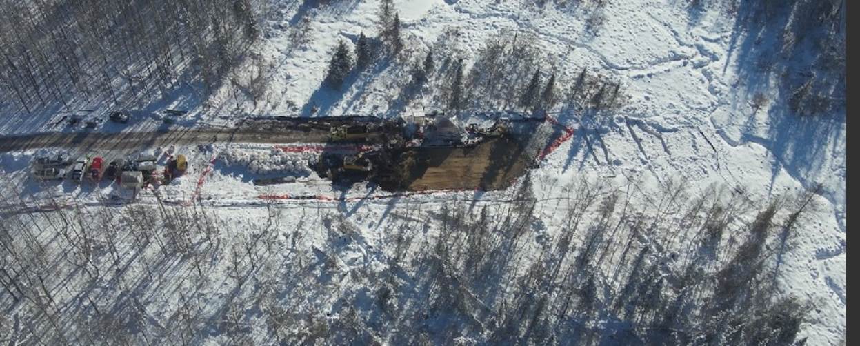
Drone view of workers removing 2.5 feet of topsoil at Walker Brook, and
replacing
it with sand, gravel,
and a little topsoil.
Other things to know:
Video available: Waadookawaad Amikwag
released this 5-minute video discussing Walker
Brook's construction damage.
Missing information: State agencies have not reported on
this location to the public, explained the type of hydrologic damage that
occurred, or their analysis of its cause.
Moose Lake breach, date unknown
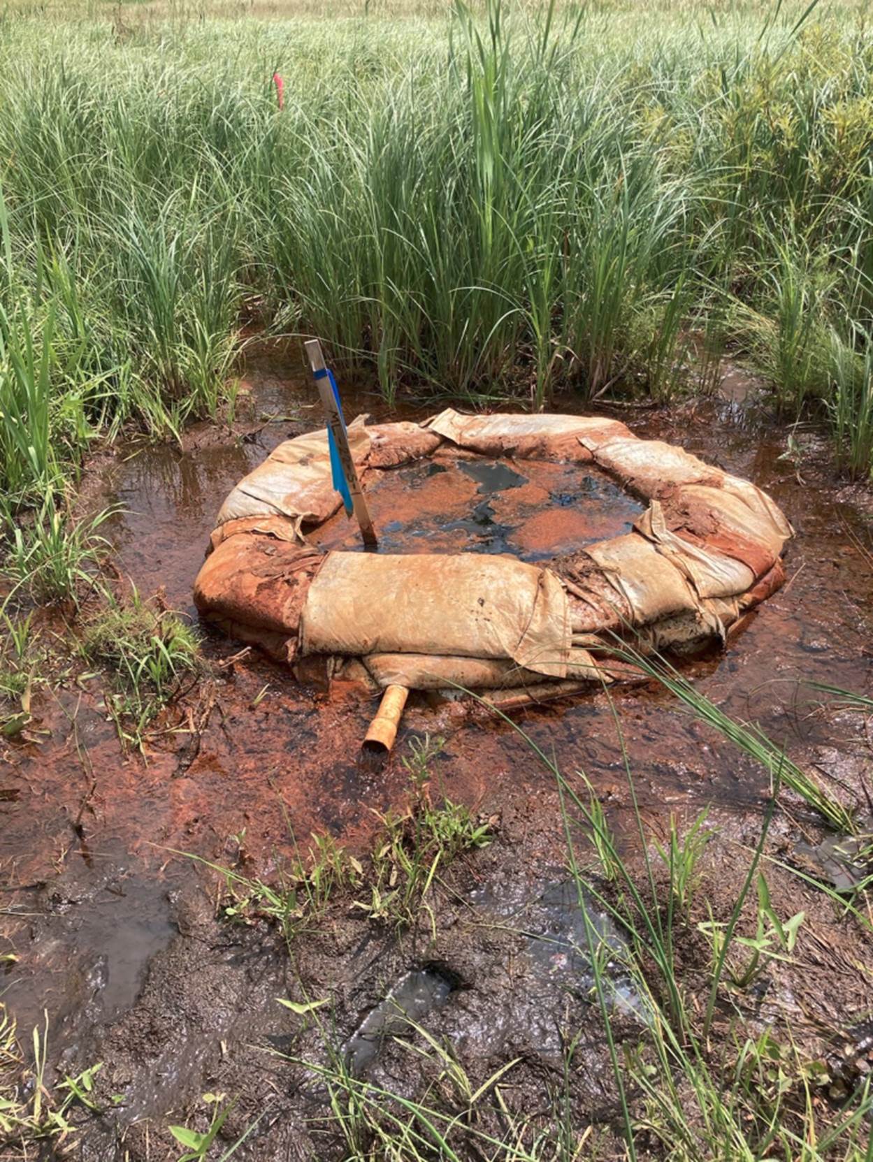
Line 3 construction near Moose Lake breached an aquifer.
Photo: Waadookawaad Amikwag, July, 2023.
Site: Construction occurred in a peat land area south of Moose Lake, a
wild rice lake in Aitkin County in 1855 Treaty Territory. Peat lands are
composed entirely of organic matter and saturated with water
Cause: Workers laid the pipeline during the winter when the ground
was frozen. Even then, workers used sheet pilings 'due to the unstable nature
of the floating mat peat in this area,' Enbridge wrote in an Oct. 3 memo to the DNR and the
MPCA. The artesian aquifer confining layer here is 16- to 20-feet deep. Workers
drove sheet pilings 28 feet deep and punctured it, according to an April 21 memo from Enbridge to the
DNR and the MPCA.
Groundwater released: Currently no estimates.
Slap-Dash Effort: Nothing yet.
How
many drops in a tidal wave?
By Chris Vaughn, www.ProtectThePorkies.com

A new study shows that a full third of mine waste is stored near or
within protected ecosystems, a trend expected to increase "due to growing
demand for energy transition metals and declining ore grades." At the
juncture of Lake Superior and Porcupine Mountains State Park, Copperwood
is the perfect example of a terrible location, but it will not be the last: if
there is not significant pushback, and soon, the shadow of mine waste will only
keep spreading.
Our fights in this region are not unique. In recent weeks many
thousands have taken to the streets of Panama in protest of a Canadian
company's copper mine' see any parallels? Environmentalists, indigenous
groups, and labor unions joined their voices so powerfully that the government
passed a moratorium on all new metal mining, and on November 28th the Supreme Court ruled the contract of the mine itself
to be unconstitutional. Common folks resorting to direct action, striking fear in
the hearts of politicians' such things happen down where the hot sauce flows
freely, but up here in Gringolandia? Can you imagine
us marching in such numbers that even the Capitol shakes, all for the sake of a mine?
I can.
Because Imagination is how it must begin. The other side knows
this: as we speak, they're imagining "a new mining district." They're
imagining the expansion of power grids, the resuscitation of railroads, and
tailings dams hundreds of feet high; they're imagining fields of wind turbines
where eagles fear to fly, and armadas of electric cars with AI so powerful you
don't even have to think about where the batteries come from; but more than
anything, they're imagining We the People, sitting on our asses, accepting
every new technology and development project to come along.
But the People are imagining too, and our petition is proof. Over 8,500
signatures show we still believe the world is capable of
doing the right thing: protecting freshwater, protecting wilderness,
protecting the right of humans to enjoy a moment of peace in Nature.
We are doing what we can to save this pristine area, and we
encourage you to visit our Take Action! page for ways to
help. But putting out the fires of every new mining project will be
extremely draining on small campaigns. Perhaps we need to imagine
bigger.
The only way to counter their "new mining district" is
with a new movement of mass resistance. Highland Copper wants to drill
beneath the Presque Isle River and extract minerals from Park land well, if
they don't respect borders, then why should we? Imagine our separate
fights in the Lake Superior region and beyond synergizing beneath a common
banner, to be legislated at the State or even Federal level: no sulfide
mining in water-rich environments, period.
Water makes up 99% of the molecules in our bodies. Water is what
unites Democrat and Republican, Michigander and Minnesotan, native and
non-native. Water is Life, yes; but if not respected, it can be something more.
Shh, listen... Do you hear the tidal wave?
Issue 1, November 9, 2023, Welcome
to a New Coalition
By Evan Zimmermann
I’m honored to present
this series of articles submitted by passionate defenders of the Great Lakes. UPE.News is the beginning of a collaborative effort between
UPEC and Citizens for a Safe and Clean Lake Superior (CSCLS). Each month we’ll
reach out to our allies and partners across the UP and the surrounding area to
highlight the many efforts underway to keep the environment and culture alive.
We start with a focus
on the conflicts that have arisen between mineral extraction and the
preservation of wilderness. We believe that it’s possible to move toward the
future while respecting the integrity of the ecosystem and all the living
beings within it, and we want you to know how this can be done and what
challenges stand in our way.
There are rarely easy
answers to complex problems, but when it comes to environmental policy, there’s
one obvious solution. It doesn’t require any new laws or extra resources. If
only our regulators would properly consult with tribal governments. Federal and
state regulators need to seek their approval before greenlighting any project
with a potential impact on their treaty rights to the land. These treaties are
the constitutional “supreme law of the land,” and when we ignore this law, we
all lose.
On Indigenous People’s
Day, I attended a conference call inconveniently placed at 10AM on a Wednesday
where the Michigan DNR invited public comments on giving Talon Metals of
Minnesota extraordinary rights to Michigan minerals. The entire public was against
it. No tribal governments were consulted by the DNR. Anyone who wanted to speak
up for indigenous stakeholders had to find out on their own about a Microsoft
Teams call in the middle of a workday and get in line with everyone else. This
would be funny if it weren’t so tragic.
I’m pleased to launch
this newsletter with a live event with representatives from Honor the Earth,
the Tamarack Water Alliance, and other engaged citizens who know more about
Talon Metals than the Michigan DNR. You can find us live on 6PM Eastern on November
9th and archived after the event at https://www.facebook.com/upenvironment/live
Thank you so much to Jane
Fitkin of CSCLS and all of our eloquent and thoughtful
contributors. You give us all hope for a sustainable future.
Index
Copperwood and the Battle for the Green Soul by
Chris Vaughn
What’s
a Wilderness by Steve Garske
Mining in the Porcupines State Park by
Nancy Stencil
Human
Health Effects of Sulfide Mining by Tamarack Water Alliance
“They
tell us to ‘shut up,’ but we aren’t going anywhere.” by
Honor the Earth
Copperwood and the Battle for the Green Soul
by
Chris Vaughn
Lake
Superior is 10% of the world's surface freshwater; all sulfide mines
contaminate water; Copperwood would be the closest
such mine to Lake Superior in history.
Hmm...
Copperwood is also less than a thirty second drive from both the
North Country Trail and Porcupine Mountains State Park, which contains the
largest tract of mixed old growth in the Midwest and was ranked last year as
"the most beautiful State Park in the country." Ecological offenses
aside, the Mine would disrupt this thriving outdoor recreation area with
nonstop industrial traffic, subterranean blasts, and air, water, light, and
sound pollution.
"Don't
worry! It's just talk!"
What
hasn't happened yet won't happen ever— a philosophy that holds... until it
doesn't. It's true Flopperwood has passed from one
failed company to the next without a single copper penny to show for it, but
this summer's developments should raise alarm in all our hearts:
1.
On July 24th, Highland Copper's market capitalization
quadrupled after receiving $30 million from Kinterra
(another Canadian company);
2.
On July 31st, the Department of Energy listed copper as a
"critical material" for the first time ever;
3.
Most importantly, forest has
been clearcut, wetlands destroyed, and streams forever altered. Future be
damned, the project is already inflicting real devastation upon
countless sentient organisms.
Apart
from the final engineering on their toxic waste facility, Highland has all the
permits to proceed. Indeed, they are but a few Canadian investors, a bank loan,
and a generous State of Michigan grant away from making this nightmare actually happen. And thanks to environmentalists, such
a grant is now more likely than ever...
"On November 3rd, lawmakers passed the
bill mandating that Michigan receive 100% of its energy from renewable sources
like nuclear, solar, wind, geothermal and hydropower by 2040." (MLive).
Here
we must address two sleights-of-hand, as common as they are dangerous:
First,
"renewable" may describe sunlight, water, and wind, but
photovoltaics, dams, and turbines do not spawn out of the aether
— to the contrary, their production demands a multitude of minerals, chief
among them: copper. So let's get an
inconvenient truth out of the way: the attempted scaling of
"green" technologies will require mining the daylights out of Planet
Earth.
Second, both the media and the bill itself have
conflated energy with electricity. Electricity
— what's really being talked about — is a mere 20% of overall energy use; the
remaining 80% will continue to be produced by fossil fuels.
Is this really enough to turn
the tide? In 2014, top Google engineers renounced their R&D project
and declared that all the alternative energy in the world won't make a dent in
climate change. Consider that the pinnacle of current offerings, the
lithium-ion battery, has an energy density of 1 megajoule per kilogram. Nice!
But diesel is 46 times that amount. No amount of
hopeful wordsmithing will lead to alt-energy replacing fossil fuels. This is in
keeping with history: new energy sources and improvements in efficiency lead
not to reduction, but to ever-increasing production (see:
Jevon's Paradox).
Thus, well-intentioned environmentalists have become pro-bono
lobbyists for massive development projects and are even condoning the
expansion of mining — among the most destructive industries on the planet. We
must all ask: if extraction, machines, and disregard for the Earth
got us into this mess, how is more of the same supposed to get us out?
The words we choose are important. In times of fear,
words lobotomize us; in times of courage, we wield the weapons ourselves. Sure,
mining and metal processing are responsible for 26% of global carbon emissions—
but arguing solely in these terms is like opposing slave ships for running on
coal. Do we protect wetlands, forests, and soil because they are carbon sinks?
Or do we protect them because they are teeming with Life? The
title "green" must either be abandoned for referring to nothing but
the emissions of an end product regardless of all that
comes before and after, or it must be reclaimed to encompass the entirety of
our relationship to the Biosphere.
Let us not shy from difficult, nuanced conversations;
they will be made easier by remembering what we stand for. Freshwater seas, old
growth forest, and the right of humans to enjoy a moment of peace in Nature —
if we don't draw a line around these things, it means we won't draw a line
anywhere. In this way, Copperwood is the ultimate
litmus test: is Civilization nothing but a suicide crusade for the God of
Progress, doomed to wrench up every last ounce of
mineral no matter the cost? Or will we find our reflections in Gitchi-Gami?
Like mycelia, our strength is in Connection. Sometimes
our hyphae will fuse; other times, division is necessary in
order to branch out. But if we continue our efforts, at once separate
and united, very soon, a potent mushroom will sprout.
by
Steve Garske
The Trap Hills region
of the Ottawa National Forest (ONF) is a special place. With its towering
forests, crystal clear streams, beaver ponds and meadows, high rock outcrops,
and awesome views, the Trap Hills have become a destination for hikers and
sightseers from the upper Midwest and beyond. Hikers climbing the Hacking Trail
from the end of Forest Road 326 to the top of the Trap Hills escarpment (the
highest sheer cliff in Michigan), are quickly rewarded with a panorama of
nearly unbroken forest, stretching from Lake Gogebic almost to Lake
Superior.
![]()
The Trap Hills are also
biologically rich and unique. The area supports mature and old-growth northern hardwood
and hardwood–conifer forests, ecological communities that are increasingly
rare. It is home to an array of North woods wildlife, including white-tailed
deer, black bear, fisher, marten, bobcats, timber wolves, beaver, porcupine,
red squirrels, and various species of mice, voles and shrews. It provides a
home for nesting birds that need interior forest habitat. It also supports a
population of state-threatened wood turtles, and at least 6 species of
state-listed, rare and endangered plants.
The fact that this
place is special is reflected in its regional following of hikers and attempts
through the years to get the area protected as wilderness. While the first two
organized efforts were led by local individuals and groups, the latest push for
wilderness designation for the Trap Hills and three other areas of the Ottawa is being led by the Environmental Law and Policy
Center of Chicago. Their Keep the UP Wild website has lots
more information on this effort.
So why has the ONF
resisted any and all attempts to even recommend the
Trap Hills as a wilderness study area? It undoubtedly has to do with the Forest
Service’s long-held philosophy that essentially all National Forest lands
should be open to “multiple use”, including (and perhaps especially) timber
harvest. Due in large part to public pressure to protect the Trap Hills core
area during the development of the 2006 Forest Plan, the
Ottawa designated this area, Norwich Bluff, and several other areas
within the forest as “Special Interest Areas”. This designation affords these
areas with some protection, but that protection could quickly disappear with an
amendment to the Forest Plan or with the next Forest Plan.
Meanwhile, the ONF
recently proposed a massive timber sale for part of the Trap Hills region. The
proposed Victoria Vegetation
Management Project
would extend from the eastern edge of the Trap Hills core area, east to
Victoria Reservoir and north to the northern boundary of the Ottawa. To the
south it would border the West Branch of the Ontonagon River, a federally-designated National Recreational River. It would
surround Norwich Bluff Special Interest Area.
The ONF’s reasoning for
not recommending the Trap Hills for wilderness consideration is included in Appendix C of the Environmental Impact Statement for their 2006 Forest Plan. In
this document the ONF cites criteria from the Forest Service Handbook in
deciding whether these areas qualify as wilderness. These criteria are
frequently at odds with the Wilderness Act of 1964.
Reasons given for
claiming that the Trap Hills region was “unsuitable” for wilderness designation
was that one could hear traffic from Hwy M-64, an assertion that is demonstrably
false. But even if this claim were true, it shouldn’t have precluded wilderness
designation for the Trap Hills. That’s because the Wilderness Act of 1964 only
pertains to the land being designated as wilderness, not the land outside the
wilderness boundary. There are many examples of wilderness areas with
boundaries that border road corridors (even 4-lane highways). Whether or not it
might be possible to hear road traffic within these areas is therefore
irrelevant to their eligibility for federal wilderness designation.
Another reason given by
the ONF for not considering at least the Trap Hills as wilderness was that it
supposedly had active roads. This is also false. The only so-called “roads”
that have ever existed in the Trap Hills core area were old horse trails used
to partly log the area well over 100 years ago. Since then, these trails have
been reclaimed by the surrounding forest and have all but vanished. Even if you
can find remnants of them, they are impassable to any sort of vehicle,
including ATVs and mountain bikes. Nonetheless the ONF has maintained these old
horse trails in their road inventory as active roads.
![]()
Another ill-informed
reason some have for opposing wilderness designation is that existing access
will be lost. However, most of these areas are already managed by the ONF as
“semi-primitive non-motorized recreation” environments. Wilderness legislation can
be written so that existing roads and the popular Pioneer motorized
recreational trail are excluded from the wilderness area and remain open as
they are now.
Under “DEFINITION OF
WILDERNESS”, the Wilderness Act of 1964 (with amendments) describes wilderness
as:
(c)
A wilderness, in contrast with those areas where man and his works dominate the
landscape, is hereby recognized as an area where the earth and its community of
life are untrammeled by man, where man himself is a visitor who does not
remain. An area of wilderness is further defined to mean in this Act an area of
undeveloped Federal land retaining its primeval character and influence,
without permanent improvements or human habitation, which is protected and
managed so as to preserve its natural conditions and which (1) generally
appears to have been affected primarily by the forces of nature, with the
imprint of man's work substantially unnoticeable; (2) has outstanding
opportunities for solitude or a primitive and unconfined type of recreation;
(3) has at least five thousand acres of land or is of sufficient size as to
make practicable its preservation and use in an unimpaired condition; and (4)
may also contain ecological, geological, or other features of scientific,
educational, scenic, or historical value.
The Trap Hills /Norwich
Bluff region and the other three areas being proposed for wilderness
designation easily fit all these criteria. Despite their remoteness and unique
features, they are vulnerable to future resource exploitation. They need to be
protected for the long-term as federal wilderness.
Mining in the Porcupines State
Park
by Nancy Stencil
![]() Sometimes
all it takes is someone sharing a photo that draws attention. “They’re planning
a mine here—not a joke.” This photo is worth a thousand words and received one hundred
shares on Facebook in a very short amount of time. This photo woke sleeping
giants that walk among us for the good. This mining project is slated for this
year.
Sometimes
all it takes is someone sharing a photo that draws attention. “They’re planning
a mine here—not a joke.” This photo is worth a thousand words and received one hundred
shares on Facebook in a very short amount of time. This photo woke sleeping
giants that walk among us for the good. This mining project is slated for this
year.
Anyone who has spent time in the
Upper Peninsula of Michigan has seen the bountiful beauty, the waterfalls, Lake
Superior, and the endless forests. The Porcupine Mountains State Park,
especially the Presque Isle scenic area, all resting on the shores of Lake
Superior, is absolutely priceless. Why would anyone
want to destroy this?
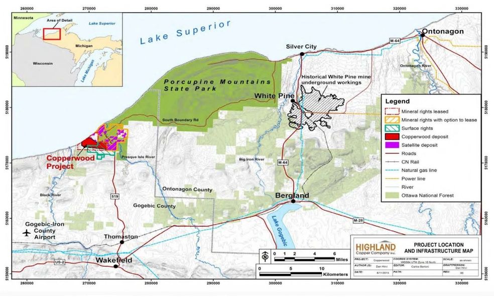
Highland Copper aims to mine
under State Park land, under the Presque Isle River, and possibly even under
Lake Superior. This would be in the west end of the Porkies. Original plans
showed the water to be drawn from Lake Superior for industrial uses. Recently,
plans changed to re-routing streams and altering wetlands. I ask you which is
worse? They are destroying precious habitat. Lake Superior holds
one-fourth of the world’s fresh water… Adding to all this, there is also
interest in redeveloping the White Pine Mine, on the east side of the Porkies,
and using this for milling the ore and storing hazardous mine
waste; forever. White Pine was initially closed around 1995, and there have
been many environmental contamination concerns such as tailing basins and
brownfields. This is ecocide and no one is taking ownership of this burden,
except maybe you and I, the taxpayer. This project will literally “bookend” the
Porkies. Picture that, a mine on each end of the Porkies. Please visit the
website www.protecttheporkies.com
We know there has never been a
sulfide mine that does not pollute. Why are our law makers allowing our waters
to be polluted with heavy metals? This is a Canadian based copper company
coming in to intentionally, and deliberately destroy our land. Copper is not a
critical mineral, and it can be much more easily recycled but this seems to
fall on deaf ears due to greed; greedy people that tell us there is no money in
recycling. The Department of Energy has placed copper on THEIR critical mineral
list, it is NOT on the U. S. Interior’s critical list. This will feed into the
lies and make it a political hot potato that will get lost in the rhetoric.
Mining companies love this. Here
is the full document.
Again, we need
to speak up, and speak up now and loudly. The clear cutting for this project
has already begun. Old growth forests are being destroyed. It's time to write to the Army
Corp of Engineers. Here's the regulations admin email: Regadmin.LRE_REGADMIN@usace.army.mil or verbally: 906.288.2833
or snail mail: 115 Lakeshore
Blvd. #C, Marquette, Michigan 49855,
Attn: Regulations Admin
The watershed of the Boundary Waters remains threatened
by toxic sulfide-ore copper mining.
by Libby London
Over the past ten years, the Campaign
to Save the Boundary Waters built a movement that brought Minnesota's
sulfide-ore copper mining threat, considered the most toxic industry by the
Environmental Protection Agency (EPA), into the national spotlight.
This year, they achieved the most significant conservation measure
to be implemented for the Boundary Waters in 45 years: a 20-year mining ban on
federal lands within the watershed of the Boundary Waters.
Unfortunately, this doesn't protect the
entire watershed from foreign mining interests - it only covers federal lands.
State land is at imminent risk. Franconia Minerals, a wholly owned subsidiary
of Twin Metals Minnesota, was just granted approval for exploratory drilling
near Birch Lake to promote a mine UNDER Birch Lake - a beloved lake that flows
into the Wilderness. Northeastern Minnesotans for Wilderness (NMW) the lead
organization of the Campaign to Save the Boundary Waters, urged the DNR not to approve
this plan. Still, nevertheless, it was approved by the MN DNR on October 30,
2023.
This proposal means that by the next
paddling season, noises of drilling, blasting, machinery, heavy traffic, and
more will drown out the natural sounds of our Northwoods - eviscerating the
quiet solitude that makes the Boundary Waters America's most visited Wilderness
area.
This dangerous drilling plan is a
flashing reminder to all Minnesota state legislators that permanent protection
of the Boundary Waters and its watershed from sulfide-ore copper mining must
include passage of the Boundary Waters Permanent Protection Bill (S.F. 167/H.F.
329).
Help us push back. We need to advocate
for permanent legislative protections and prepare for our crucial legal battle
next year - you can help us move these measures forward by getting involved at SavetheBoundaryWaters.org
Human Health Effects of
Sulfide Mining
![]() Dr. Jennifer Pearson and Dr.
Emily Onello and other colleagues summarize their
priority for addressing the proposed sulfide-ore copper nickel (SOCN) mining
project in Tamarack with the statement, “There is no hard and fast science that
has yet proven cause/effect to human health, but rather a ground-swell of
concern by healthcare professionals given the harmful effects to human health
of the heavy metals/sulfates that will forever leach from the mining sites.
Part of the ask has been that this science/assessment be baked into any EA or
EIS moving forward.”
Dr. Jennifer Pearson and Dr.
Emily Onello and other colleagues summarize their
priority for addressing the proposed sulfide-ore copper nickel (SOCN) mining
project in Tamarack with the statement, “There is no hard and fast science that
has yet proven cause/effect to human health, but rather a ground-swell of
concern by healthcare professionals given the harmful effects to human health
of the heavy metals/sulfates that will forever leach from the mining sites.
Part of the ask has been that this science/assessment be baked into any EA or
EIS moving forward.”
With the context of
SOCN mining being considered in water-rich Minnesota, and given pollution
resulting from SOCN mining elsewhere, Pearson and colleagues have written about
the need for careful scrutiny in examining the associated risks.
“Recent federal
decisions to reinstate mineral leases and abort the environmental assessment
process have placed our unique and irreplaceable region at substantial risk.
The overall health and wellness of this region will very likely be negatively
affected by SOCN mining, and economic costs will predictably outweigh benefits.
In addition, negative impacts on water, fish and wild rice will likely degrade
nutritional and tribal resources resulting in violation of usufructuary rights
of tribal communities,” Pearson says.
Dr. Pearson and her
colleague Dr. Emily Onello will speak om Thursday,
October 5, 2023 about the changing legislative and permitting landscape around
permits and leases for hard-rock mining, in particular the effects the changes
will have with regard to human, wildlife and environmental health in Minnesota.
They will also explain how Minnesota’s health care providers are mobilizing to
inform the public about the potential risks of mining to Minnesotans.
In their
article Sulfide-ore mining and human health in Minnesota, Pearson
and Onello and colleagues point out the,
“Inextricable connection between ecosystem health, animal health and human
health . . . and the toxic track record of sulfide-ore mining elsewhere,”
saying that, “concern for human health must be part of the public dialogue.”
In the same article,
Dr. Pearson cites the World Health Organization as listing 10 environmental
toxins that are of the greatest concern to human health, and states that SOCN
mining like that being proposed for Aitkin County has the potential to release six
of these including mercury, lead, arsenic, cadmium, asbestos and particulate
air pollution. Sulfide-ore mining also releases sulfates that promote
methylation of elemental mercury already present in wetlands and sediments.
Copper-nickel ore
frequently contains iron sulfide minerals such as pyrite (FeS2), one of the
world’s most common sulfide minerals. The atmospheric oxidation of pyrite
ultimately results in the release of sulfuric acid. Under certain
conditions, ferric iron (Fe3+) remains soluble in acidic outflows and forms the
reddish-orange to yellow ferric hydroxide (Fe(OH)3), a
precipitate often recognized as the hallmark of waters containing acid mine
drainage.
A key difference
between the majority of the copper sulfide mines
currently operating in the United States and those proposed for Minnesota is
that most are located in the Southwest, a region that receives little rain and
snow. Those environments minimize communication between surface and groundwater.
In wetter climates like Minnesota’s, surface and shallow groundwater are more
vulnerable to the negative effects of sulfide mining. More detail on this issue
can be found in the article, Sulfide Mining and Human Health in
Minnesota, co-authored by Dr.Pearson
and Dr. Emily Onello and other colleagues.
We look forward to
having you join us for this interesting presentation. Links to three
papers providing more in depth treatment of the issues
are listed here:
Resources Consulted
- Sulfide
Mining and Human Health in Minnesota, National Library of Medicine, Nov.
2016, https://pubmed.ncbi.nlm.nih.gov/30476429/
- Risks
and Costs to Human Health of Sulfide-Ore Mining Near the Boundary Waters
Canoe Area Wilderness
Human Health and Ecological Assessment, Feb. 2019, https://www.tandfonline.com/doi/full/10.1080/10807039.2019.1576026 - Sulfide
Ore Mining and Human Health in Minnesota, March/April 2022 p.33-38, https://www.mnmed.org/application/files/2916/6913/9688/Mar-Apr-22.pdf
“They tell us to ‘shut up', but we aren’t going
anywhere.”
A green economy can only be built
with respect for water and treaty rights.
Recently, an article by the Washington Post
asked the question, Is
sustainable mining possible? Even in the title of that piece –
which asserts that “The EV Revolution depends on it” – it’s clear that the measure
of sustainability automakers and mining industry advocates are aiming for is
deeply flawed. In this era of climate chaos and global instability, the
measure of whether or not we can achieve
sustainability of our climate or economy should not be a question of sustaining
the highest level of corporate extraction and profiteering, but whether or
not our most vulnerable communities will survive and thrive into the future.
Native communities on the front lines of climate change
and extractive industry have seen this before with the oil and gas industry.
They’ve long borne the brunt of destructive and careless industrial
development. A green economy cannot be built on the continued destruction
of lands and waters, or by silencing Native opposition. The tiny town of
Tamarack in Aitkin County has become one focal point for these conversations
about the future, because Rio Tinto and their exploration partner Talon Metals
are banking on receiving permits to mine here.
![]() A massive deposit of nickel and
copper, bound-up in sulfide ore, sits beneath a wetland on the outskirts of
town – a place that is connected to many other places by water – including
numerous lakes and rivers that flow into the Mississippi River. This is not
just a rural town “in the middle of nowhere” as some people imply. This is
Anishinaabe territory, and home to some of the most important wild rice lakes
in the world. Native people retain the rights to hunt, fish and gather from
these lands, which are also a source of life and livelihood for many other
families and communities. A new mining boom would compromise Indigenous rights
and livelihoods, because it would put that very land and the lives that depend
upon it at risk for generations.
A massive deposit of nickel and
copper, bound-up in sulfide ore, sits beneath a wetland on the outskirts of
town – a place that is connected to many other places by water – including
numerous lakes and rivers that flow into the Mississippi River. This is not
just a rural town “in the middle of nowhere” as some people imply. This is
Anishinaabe territory, and home to some of the most important wild rice lakes
in the world. Native people retain the rights to hunt, fish and gather from
these lands, which are also a source of life and livelihood for many other
families and communities. A new mining boom would compromise Indigenous rights
and livelihoods, because it would put that very land and the lives that depend
upon it at risk for generations.
The devastating impacts of mining are not only a
concern for Indigenous people, although these frontline communities are most at
risk, and are preparing to shape a truly sustainable future. Manoomin, or sacred wild rice, is an indicator of the
overall health of waters, lands and our economies. Protecting wild rice and
clean water is a climate change solution. Gaa-mitaawangaagamaag-ininiwag,
or the Sandy Lake Band of Chippewa, are featured in this article because they
are at risk from Rio Tinto and Talon’s development of sulfide ore mines here.
“This area is just too precious to
leave to chance. [Just as] the wind travels, toxic air will travel. It will
come into the lakes. It will devastate the fish. It will devastate the wild
rice. It will.”
— JEAN SKINAWAY-LAWRENCE, SANDY
LAKE BAND OF MISSISSIPPI CHIPPEWA, AT LAKE MINNEWAWA.
Sandy Lake is asking other Native communities and
non-native allies to join them in calling out Rio Tinto’s land grab, and
Talon’s greenwashing – re-asserting that these are places worth protecting.
“This area is just too precious to leave to chance,” said Jean
Skinaway-Lawrence, chairwoman of the Sandy Lake Band of Mississippi Chippewa.
Native and non-native people in and around the mine are becoming more concerned
about the risks of sulfide mining in this water rich region.
Click here to read more about the risks of
the Rio Tinto / Talon mine and about some of the Indigenous-led solutions to
climate change being developed here.